Hiking & Biking in Adams County

Adams County Rock Formations
Adams County has 23 well-known rock formations and lesser-known rock outcroppings. The most popular of all the formations is Roche-A-Cri Mound located just north Adams - Friendship. You can see Friendship Mound from the main street in town. Some of the rock formations have become waysides for motorist to stretch out their legs and enjoy a little of what Central Wisconsin has to offer.

Roche-A-Cri State Park
Located north of Adams - Friendship, the park has more than five miles of ground-level hiking trails, campsites, picnic areas, a picnic shelter for up to 80 people, a playground, volleyball and horseshoe courts, and fishing for pan fish or brook and brown trout in Carter Creek. This is a popular site for geocaching. The park is open year-round from 6am - 11pm. The summer entrance is located on Highway 13, during the winter the park is accessible through the entrance on Czech Avenue.
D.R.A.F.T.

D.R.A.F.T. - Discover Rome Area Family Trails is a group of Rome residents whose objective is to make silent (non-motorized) sports safer and more accessible to everyone!
For more information regarding the D.R.A.F.T group or biking and hiking trails in the Town of Rome - draftromewi@gmail.com.
Witches Gulch

Witches Gulch offers an eerie yet incredible walk through a slot canyon just off the Wisconsin River, above the dam in Wisconsin Dells. A short boardwalk trail winds through this stunning area, showcasing dramatic sandstone cliffs covered in lush green moss that tower above you. Along the way, you’ll encounter Witches Falls and Witches Bathtub, a small waterfall and creek that runs beneath the boardwalk.
This amazing place is accessible only via the Upper Dells Boat Tour, which navigates through a channel carved by ancient glaciers, featuring numerous cliffs and sandstone formations. Witches Gulch is one of two land stops on these boat cruises, the other being Stand Rock, a towering sandstone pillar. Due to the drop in temperature within the slot canyon, visitors are advised to wear at least a light jacket, regardless of the season, adding to the eerie atmosphere. At the end of the Witches Gulch trail, you’ll find a concession stand and bathrooms, making this one of the more unique places to visit in southern Wisconsin!
Van Kuren Trail
The Van Kuren Trail is a 3.2-mile hike and skiing trails adjacent to the Petenwell Flowage. The route travels through a variety of different habitat types, increasing the opportunity for wildlife observation. The trail also passes through an existing wildlife observation tower, where hikers and skiers can take a break. There is a warming shelter in the winter. The trail is well-marked. The trail is located in the town of Strongs Prairie, off Chicago Avenue.
Chester School Forest
The Chester School Forest is a result of a cooperative effort between the Nekoosa School District and the Town of Rome. The school district, DNR representatives, students, teachers, UWSP LEAF Coordinators, Town Officials, and staff have been working since March of 2015 to restore the school forest located on Alpine Dr. Plans for the 40-acre parcel include a shelter building, extensive trail system, flora and fauna markers and an outdoor “Theatre” for naturalist programs and entertainment.
For more information contact Mr. Terry Whitemore at Terry_whitmore@nekoosa.k12.wi.uw
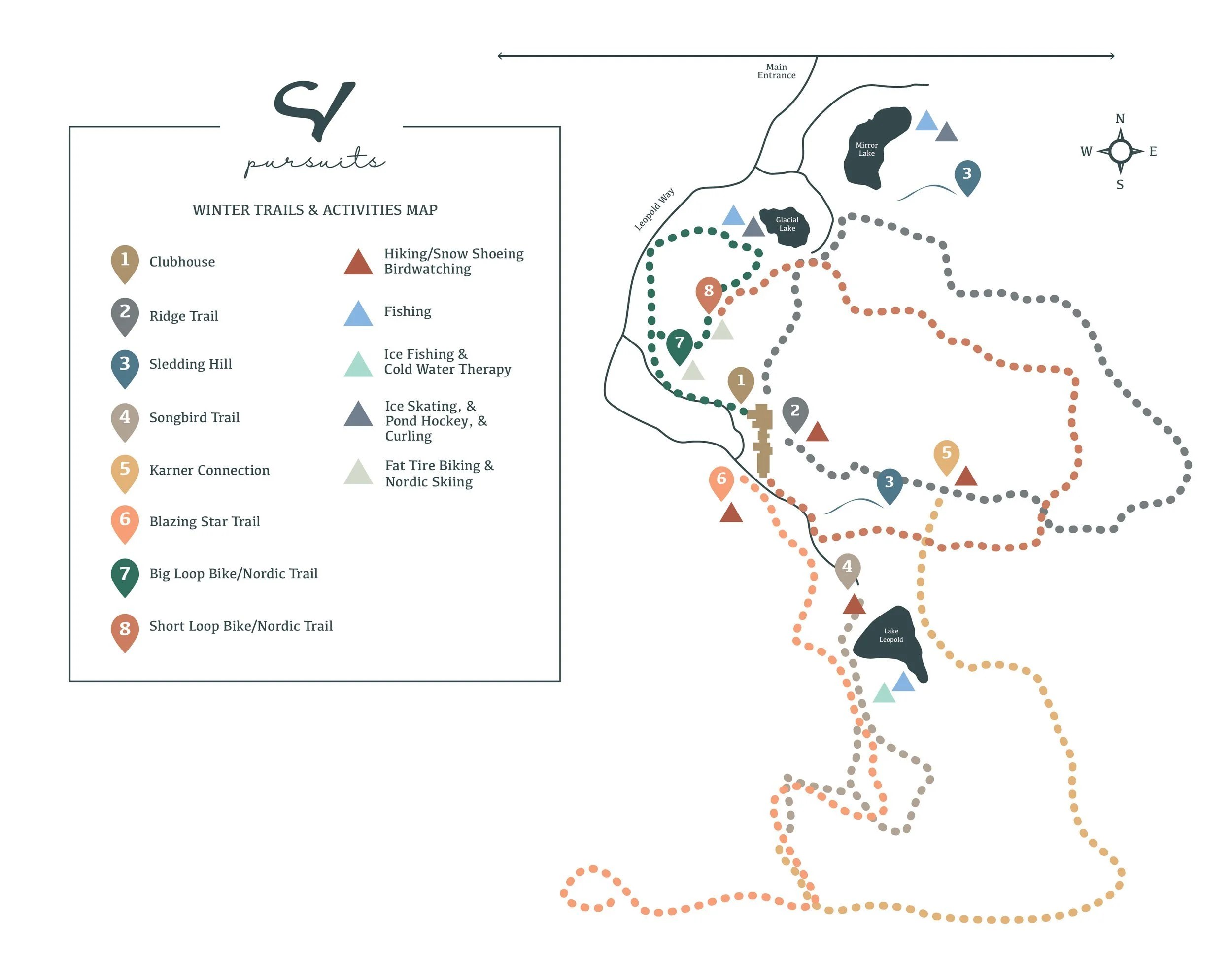
Sand Valley Hiking & Biking Trails
For a map of Sand Valley’s Hiking & Biking Trails, pick up a copy from the Sand Valley Clubhouse.
The hiking trails in winter become snowshoeing trails.
For your safety and the safety of others always stay on the designated groomed hiking & biking trails.
Karner Connection Trail
Trailhead location Meditation Point of the Songbird Trail or about ½ mile into the Ridge Trail.
Length: 1.5 Miles|Difficulty: Moderate|Hiking Trail
Connecting the Ridge Trail to the Songbird Trail the Karner Connection is perfect for hikers & snowshoers looking for extra miles. This trail features Sand Valley’s Karner Blue Butterfly habitat, various aged red pine plantations, and views of Lake Leopold. Traversing ridges and valleys this trail highlights the beautiful topography of the area. This is a connecting trail – hikers & snowshoers must hike part of the Ridge Trail or Songbird Trail to access the Karner Connection.
Songbird Trail
Trailhead location: Behind Craig’s Porch at the North end of Sand Valley’s Driving Range.
Length: 1.2 Miles|Difficulty: Moderate|Hiking Trail
Starting at the North end of the Sand Valley Driving Range the trail traverses through a sampling of restoration/remnant areas, past golf landscapes, and through an intact red pine plantation. Take note of the bird boxes located along the trail – the lifecycle of songbirds is monitored by volunteers throughout the summer. The Songbird Trail is a loop trail - starting behind Craig’s Porch then taking hikers & snowshoers to a meditation point before looping back to the trailhead.
Ridge Trail
Trailhead location: South End of Clubhouse. Length: 2.5 Miles|Difficulty: Advanced|Hiking Trail
Starting at the South end of the Clubhouse the trail traverses along the V ridge of the Mammoth Dunes Golf Course. The trail features expansive sand blowouts, red pine plantations, and majestic oak savannah. Hikers & snowshoers will enjoy spectacular views of Mammoth Dunes Golf Course or a snow-covered Mammoth Dunes in winter, including vistas along ridges as high as 80 feet above the golf course. The trail ends at the North end of the Sand Valley clubhouse by the bocce ball courts.
BLAZING STAR TRAIL
Trailhead Location: Across the street from the South end of the Clubhouse.
Length: 3 miles|Difficulty: Advanced|Hiking Trail
Starting across the street from the Clubhouse's south end, the trail traverses the less traveled road. This trail is known for taking hikers to the corners of the property away from golf and into the forest. The Blazing Star Trail joins up with the Songbird Trail at times and sometimes crosses it. Make sure to follow the yellow arrows to experience Central Wisconsin’s quiet wilderness fully.
SHORT LOOP
Trailhead Location: Clubhouse
Length: 1 mile|Difficulty: Easy|Biking Trail
Starting at the Clubhouse, the trail allows riders to see the Sandbox in a new way. The groomed trail features some tight turns and tumbling sand dunes or snow-covered dunes. This trail is accessible and fun for the whole family! Riders will enjoy views of Sandbox and a standing Red Pine plantation. The trail is a loop ending back at the Clubhouse.
BIG LOOP
Trailhead Location: Clubhouse
Length 2.5 miles|Difficulty: Moderate |Biking Trail
Starting at the Clubhouse, the trail allows riders a more challenging fat tire bike ride. The trail features a couple of steep climbs, vast views of Mammoth Dunes Golf Course or a snow-covered Mammoth Dunes in winter, and an immersive experience with nature. In the end, the final climb gives way to a nice downhill ride back to the Clubhouse.